%201_opt.jpg)
The Most Undervalued Layer of Aerospace
Introduction
Roughly every ten days, there is a billion-dollar weather catastrophe in the United States. Between the news headlines, ecosystems are shifting, infrastructure is aging, and the gap between what aerial data can show about these events and the truth on the ground keeps widening. Today, the systems we depend on, from shelter to energy, food, and transportation, are under mounting pressure from rapid changes across our planet. The aerial observation methods previously relied on to monitor them were not designed for this reality. They either operate too close to the Earth’s surface, sacrificing field of view, or too far from it, sacrificing resolution.
Geospatial data capture has been defined by two platforms for almost 80 years: fixed-wing aircraft and satellites. Neither was built to deliver what modern situational awareness actually demands. Organizations that depend on Earth observation have been forced into a persistent trade-off: wide-area coverage at low resolution, or high-resolution coverage with limited scale and infrequent refresh. That tradeoff has produced generations of trailing, imprecise insights, and the cost of those imprecise insights is compounding.
Yet, between 45,000 and 100,000 feet, there is a layer of airspace that has been largely ignored for commercial innovation: the stratosphere. It sits above ground weather, commercial air traffic, and restricted airspace, but remains close enough to Earth to capture imagery at resolutions that satellites cannot match. Today, pioneers are deploying new technologies in the stratosphere to address the growing need for better aerial observation, proving that this layer of Earth’s atmosphere has been overlooked for too long.
The stratosphere is a fundamentally different layer for innovation, with physics advantages that no other modality can replicate. Imagery is just the beginning. The stratosphere has potential for communications, persistent sensing, and infrastructure monitoring that is only starting to be understood.
Ground Truth Is Changing Faster Than Our View of It
In 1921, Sherman Fairchild strapped a custom-built camera to the belly of a biplane and began photographing New York City from the air, one overlapping frame at a time. The resulting mosaic gave city planners something they’d never had: a complete, accurate picture of the ground below, assembled not from surveyors’ notes but from a single continuous vantage point in the sky. Within a few years, Fairchild’s aerial surveys were mapping farmland, coastlines, and entire regions for governments and industries that had never been able to see their own footprint this clearly. For the first time, humans could observe the Earth from above at scale, and act on what they saw.
That was roughly a century ago. The aircraft have gotten faster and the cameras sharper, but the fundamental approach hasn’t changed. Planes still fly lawnmower patterns over survey areas. Satellites, introduced in the 1960s, orbit hundreds of miles above the surface. For most of the intervening decades, the pace of change on the ground was slow enough that this was adequate. Imagery captured once a year, or even less frequently, was sufficient for the decisions being made.
That world no longer exists.
Today, a billion-dollar weather disaster strikes the United States roughly every ten days, and the annual cost of weather-related damage has quadrupled since the 1980s. Shifting population patterns are pushing communities deeper into vulnerable geographies. This includes the wildland-urban interface, floodplains, and earthquake-prone areas, where landslides, mudflows, and sinkholes threaten properties that were considered safe a decade ago. And the buildout of data centers and next-generation power infrastructure is creating new monitoring demands within energy, transportation, and utilities, layered on top of aging systems that were already difficult to track.
The gap between what is happening on the ground and what the data shows has never been wider, and it continues to grow.
The Cost of Outdated Aerial Imagery Is Immense
The costs of stale imagery ripple differently across every industry that depends on it, but the pattern is the same: distance from the present moment becomes risk. Property and casualty insurers find properties harder to underwrite accurately, claims slower to validate, and fraud easier to hide behind outdated records. State and local governments lose precious time managing emergency response systems, public works, and critical infrastructure when their geographic data lags behind reality. Vegetation encroaches on transmission corridors and fuel moisture declines near power lines invisibly, leaving risk to accumulate that utilities don’t see until it surfaces as a wildfire or a Public Safety Power Shutoff. Forests decline, and crops falter in ways that could have been caught early, but go undetected until the damage is irreversible. Technology companies building navigation products and location-based services watch stale basemaps cascade into unreliable models and analytics, slowly eroding the customer trust those products depend on. And for roofing contractors and home services companies, outdated property data is simply a competitive liability: not having the most up-to-date view of a neighborhood means losing valuable business.
The challenge of seeing the Earth clearly, frequently, and cost-effectively spans all of these sectors. And the platforms currently tasked with doing that job were not designed for this moment.
Other Observation Technologies Were Built for a Different Era
Earth observation has always been a function of altitude. For most of the field’s history, operators have worked from one of two layers: the troposphere, which occupies the area between the Earth’s surface up to roughly 40,000 feet, and outer space, which is situated hundreds of miles above Earth. Both layers have produced a generation of capable technology with real, hard ceilings.
Drones operate in the lower troposphere, typically below 400 feet. The resolution is excellent over small areas, but the coverage is not. Replicating wide-area survey data with drones requires hundreds of flights and stitching together millions of individual image scenes — a logistical and data-processing challenge that makes large-scale drone surveys commercially unviable. Regulatory restrictions on drones, particularly in urban areas, add further constraints.
Fixed-wing aircraft operate higher in the troposphere, typically between 5,000 and 15,000 feet. They deliver higher resolution than satellites and meaningful coverage across metropolitan areas. But they fly inefficient lawnmower patterns, are expensive to operate, and struggle to meet the refresh cadence required by modern risk monitoring.
Satellites operate far above Earth, typically between 100 and 1,200 miles up. This obviously provides a wide coverage area, but resolution becomes the issue. Achieving 7cm Ground Sample Distance from orbital altitude would require a telescope roughly 10 to 14 feet wide, deployed in low Earth orbit, which is impractical at the cost and scale needed for wide-area commercial coverage. Additionally, standard satellite revisit rates are often unpredictable; when multi-hundred-million-dollar development and launch costs are in play, defense mission priorities tend to take precedence over commercial tasking.
However, between the troposphere and outer space sits the stratosphere, roughly 8 to 30 miles above the surface. It has been largely ignored as a functional layer for Earth observation, mostly because the technology to unlock value from this altitude simply did not exist until now.
Why a Fourth Modality Is Needed Now
Three forces are simultaneously making the limitations of legacy platforms untenable.
The pace of change on the ground has accelerated well beyond what existing refresh cycles can keep up with. What was barely adequate 15 years ago is now dangerously slow.
The cost of having missing data or being caught flat-footed is higher than ever. The infrastructure
at stake (power grids, public works, homes, and natural ecosystems) is becoming exponentially more expensive to repair and replace.
The rise of AI is lifting the floor on data quality across every workflow that touches Earth observation. Computer vision models, risk algorithms, and autonomous decision systems are only as good as the imagery they ingest. Degraded, infrequent, or low-resolution data does not just limit insight. At scale, it corrupts model outputs in ways that are difficult to detect and expensive to correct. Regulators are taking notice of this. Several states have already passed laws requiring imagery used in insurance underwriting to meet minimum recency standards, and more are proposing stricter limits on how old aerial data used in coverage decisions can be.
The world needs a more efficient and economical method for aerial observation, and the answer lies in a layer of the atmosphere that has been infrequently leveraged until now.
The Stratosphere: Earth’s Most Valuable Untapped Layer
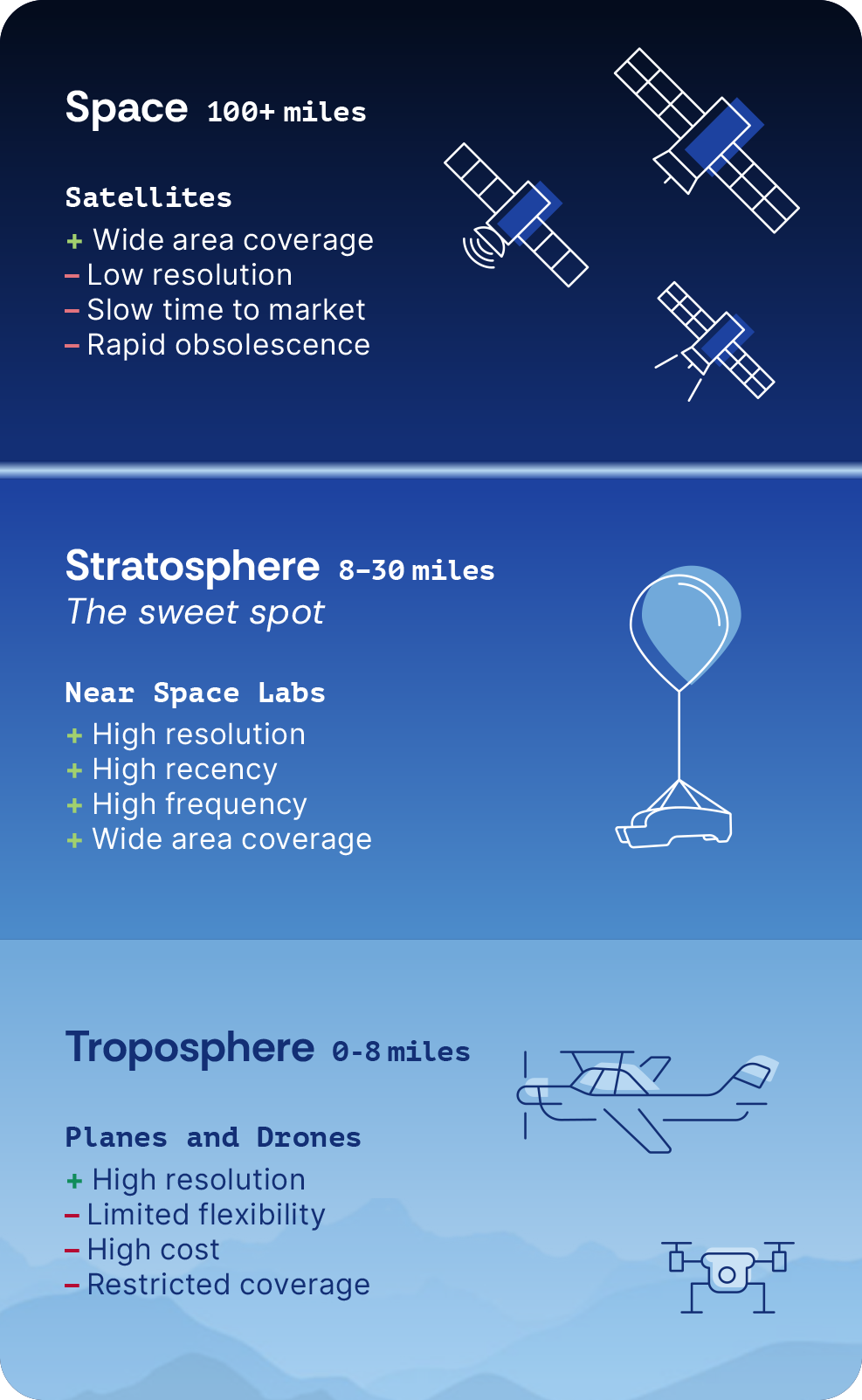
The stratosphere sits 45,000 to 100,000 feet above Earth. It is higher than ground weather, commercial air traffic, and temporary flight restrictions, yet still close enough to Earth to deliver imagery at resolutions that orbital altitude cannot match. In concept, it is the ideal platform for Earth observation. In practice, getting there and making it work commercially has eluded aerospace engineers.
In some ways, the stratosphere can be harder to operate in than space. Satellite operators benefit from decades of proven manufacturing, standardized components, and well-understood orbital mechanics. Stratospheric operators are largely building novel systems from scratch, with fewer established supply chains and far less institutional knowledge to draw from.
The stratosphere itself is unforgiving. Temperatures are extreme, with large thermal swings during ascent and operations. Solar radiation is also significant. Beyond these environmental factors, the physics of flight create their own distinct collection of challenges. Fixed-wing aircraft can’t generate enough lift in the thin air of the stratosphere, and conventional propellers lose efficiency rapidly at high altitudes. Balloons and airships face a different problem: maintaining lifting gas across long missions adds cost, complexity, and operational risk. And unlike satellites, which trace predictable orbital routes once in position, stratospheric vehicles are subject to winds that must be actively navigated on every single flight.
Prior attempts to open this layer for commercial use have followed the satellite playbook: large, fixed-cost assets designed for predictable station-keeping, with high upfront development costs underwritten by the hope that unit economics would eventually catch up. The problem is structural. When the asset is enormous and fixed, the economics demand a single customer large enough to carry it — and that customer has almost always been a defense or government buyer. Commercial requirements get shaped around that buyer’s priorities. Roadmap, tasking, and sensor decisions all follow. Commercial customers receive whatever capacity remains. The stratosphere has been reached before. Making it work at commercial scale, for commercial buyers, at commercially competitive prices, is the problem that has gone unsolved.
What is changing today is the engineering philosophy. Rather than fighting the stratosphere’s conditions, the operators beginning to unlock this layer are working with them: using wind currents for navigation rather than burning fuel to fight them; building modular and redeployable vehicles rather than single-purpose fixed assets; and designing for operational nimbleness so that platforms can be recovered, reconfigured, and relaunched rather than locked into a single mission profile.
Five Properties That Make the Stratosphere Uniquely Valuable
Once the engineering problem is solved, the physics of the stratosphere becomes a significant and durable competitive advantage.
Altitude advantage: At 45,000 to 100,000 feet, stratospheric vehicles fly two to four times higher than traditional fixed-wing aircraft. That altitude translates into a field of view roughly eight times larger per flight pass: 7.5 square miles versus 1 square mile for a fixed-wing aircraft at a typical survey altitude. More ground covered per flight means fewer flights, lower operating costs, and faster turnaround on large-area surveys.
Above the weather: Ground weather conditions that prevent fixed-wing aircraft from flying — such as strong winds, smoke from wildfires, and low visibility — do not affect stratospheric operations. Flights proceed on schedule regardless of what is happening in the lower atmosphere.
Above the traffic: The stratosphere sits above commercial air traffic corridors and above the altitude at which most Temporary Flight Restrictions (TFRs) apply. For example, a stratospheric vehicle can maintain operations over an active wildfire when other aerial assets have been grounded.
Below the resolution ceiling: Satellites are constrained by the physics of their altitude. Achieving a 7cm Ground Sample Distance from orbital height would require a telescope roughly 10 to 14 feet wide in low Earth orbit: an impractical proposition for commercial wide-area coverage. The stratosphere makes high-resolution, wide-area capture achievable without that constraint.
Minimal footprint: Operations at 45,000 feet take place far above communities, wildlife, and sensitive ecosystems. There is no noise, no habitat disturbance, and no restriction on flying over protected areas. The stratosphere offers a genuinely non-invasive vantage point, a meaningful advantage for environmental monitoring applications where ground disturbance is not an option.
What the Stratosphere Actually Unlocks
Think of the atmosphere as a Goldilocks problem. Too low, and you get resolution without reach: a drone that can count the shingles on one roof, but cannot survey a county. Too high, and you get reach without resolution: a satellite that can see a city, but cannot tell you whether a specific power line has vegetation growing into it. The stratosphere is the layer that is just right. High enough for wide-area coverage and cost-effective operations, and close enough to Earth for the structural detail that modern analytics and AI workflows actually require.
That translates into four capabilities delivered simultaneously, without compromise.
7cm resolution everywhere: Details at the level of individual roof shingles, vegetation encroachment on a transmission line, or cracks on a highway. The same clarity whether the survey area is downtown Miami or a rural county in Montana, with no degraded coverage.
Frequent data capture: The stratosphere enables a refresh cadence that other platforms cannot match at this combination of resolution and scale. Organizations get a current, reliable view of ground truth rather than making high-stakes decisions on imagery that is months or years out of date.
Wide-area capture at speed: A stratospheric vehicle can cover a city the size of Los Angeles in an afternoon, a survey area that would take fixed-wing aircraft days to complete. That combination of scale and speed opens up use cases that were simply not serviceable on previous timelines.
Cost-effective operations: High-altitude flight maximizes the data captured per flight hour. The result is frequent, wide-area monitoring that is economically viable for local governments and small businesses, not just large enterprise customers who can absorb the cost of legacy platforms.
Where the Stratosphere Wins Today
Stratospheric Earth observation with optical RGB (Red, Green, Blue) sensors has already been proven commercially viable for applications in property and casualty insurance and state and local government. These mark the first payload and end-market combinations to move from concept to operating reality, but the same platform is ready to extend to other sensors and markets.
Underwriting and risk modeling for property and casualty insurance. Consistent 7cm imagery across every market, including rural and lower-priority areas that legacy programs deprioritize, allows accurate underwriting without coverage gaps. Pre-event baseline imagery validates claims and reduces fraud. Frequent capture means that when a weather event occurs, adjusters have recent imagery to compare against, improving the entire claims workflow.
State and local orthoimagery programs. Geographic Information System (GIS) databases updated every few years are no longer adequate for infrastructure planning, ecosystem monitoring, or risk mapping. A predictable, frequent refresh schedule matches government procurement cycles, and data integrates directly with the platforms that stage agencies and GIS offices already use. Consistent 7cm resolution holds across entire jurisdictions, whether urban center or rural outpost.
Wildfire mitigation. Consistent fuel load monitoring and vegetation density assessment before fire season, not just post-event damage capture, gives land managers and utilities the information they need to intervene before conditions become critical. Near-infrared (NIR) capabilities assess vegetation health and soil moisture across vast, hard-to-reach terrain. And when active TFRs ground fixed-wing aircraft during a fire event, stratospheric vehicles can continue operating overhead.
Beyond these anchor use cases, the same data foundation supports roofing and home services companies in identifying leads and assessing property conditions without site visits, technology companies in building navigation products and location-based services that require high-resolution basemaps, and forestry and agricultural operators in tracking immediate changes in land and crop condition that require speedy intervention.
Pioneers of the Stratosphere: How the Layer Is Finally Being Put to Work
The Integration Problem Nobody Else Solved
Other operators have demonstrated that the stratosphere is accessible. Companies like Urban Sky and WindBorne have shown that vehicles can reach this altitude and return. What has proven far more difficult is making stratospheric operations work as a repeatable, commercial-grade system: one that deploys at scale, recovers and relaunches quickly, processes data automatically, and delivers analysis-ready output at a cost that competes outside of defense contracting.
The reason prior attempts stalled was not due to any single, unsolved engineering problem — it was the challenge of integrating multiple innovations into an end-to-end tech stack. Stratospheric imaging systems, flight operations software, data processing, and scalable manufacturing: each piece is solvable in isolation. Orchestrating all of them in a unified product is what changes the economics. Integration drives down the marginal cost of each additional mission to the point where the numbers work
for commercial buyers, not just defense programs with massive budgets. That is how a stratospheric platform escapes the costly pilot trap and earns repeat customers rather than one-off contracts.
The Vehicle
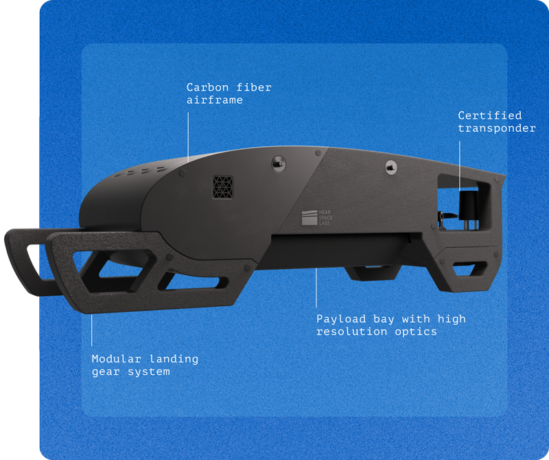
The Swift, Near Space Labs’ stratospheric imaging robot, requires no engines, no pilots, no special flight licenses, and no airfield. Missions launch in under 20 minutes from a roadside setup, as far as hundreds of miles from the target area. The platform is entirely wind-powered in flight, producing zero emissions from launch to landing.
The Swift is designed for modularity and extensibility. New sensor types — thermal infrared (TIR) for wildfire detection, near-infrared (NIR) for vegetation health, custom sensors for infrastructure monitoring — can be integrated in weeks as mission requirements evolve. The platform is built to adapt rather than be replaced.
The Operations
Near Space Labs works closely with aviation regulators, and every mission is coordinated directly with local Air Traffic Control (ATC) and the Federal Aviation Administration (FAA). In addition, every vehicle flies with Automatic Dependent Surveillance-Broadcast (ADS-B) transponders from launch to landing.
Fleet coordination is managed through Near Space Labs’ proprietary flight operations software. Multiple Swifts can be coordinated in a single mission, autonomously covering hundreds of square miles. To put the scale in context: a single Swift mission covers approximately the area of the Washington D.C. metropolitan area in a few hours. Achieving the same coverage with drones would require roughly 800,000 individual flights over many weeks, and stitching together millions of resulting image scenes would be unworkable at a commercial scale. A satellite covering the same area cannot achieve the same resolution.
The Data Pipeline
The Swift captures the data. What Near Space Labs delivers is intelligence.
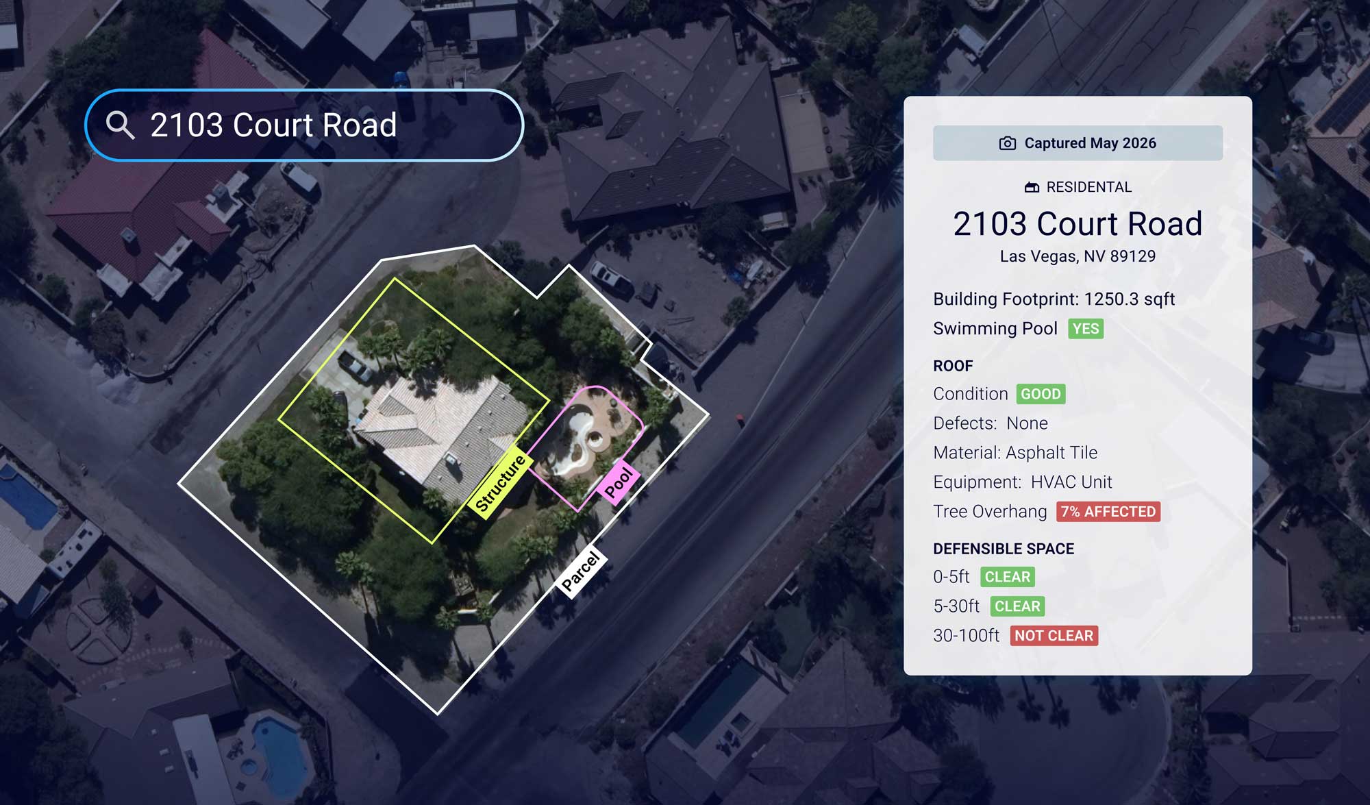
An AI-powered processing pipeline georectifies, orthorectifies, and normalizes imagery without manual quality assurance, reducing the time from capture to analysis-ready delivery from the months typical in traditional geospatial workflows to days or weeks. All imagery is Open Geospatial Consortium (OGC) compliant, ready to feed directly into GIS platforms, computer vision models, and analytics workflows without additional processing overhead.
The 7cm resolution that the Swift captures gives AI models considerably more to work with: granular structural features, vegetation health indicators, surface conditions, and ecological changes at a level of detail that was simply not achievable at the data quality levels of legacy imagery providers. High-quality data in, high-quality decisions out.
The Stratosphere Is Just Getting Started
Pioneers in the stratosphere, like Near Space Labs, have already proven the layer works. The company operates one of the largest commercial fleets of stratospheric vehicles, with continental U.S. coverage delivered on a regular cadence that is autonomous from launch to landing. That operational track record is the foundation, but what gets built on top of it is still being written.
The same physics that make the stratosphere ideal for Earth observation (altitude, persistence, wide field of view, stability above weather systems) make it a leading candidate for communications relay, persistent environmental sensing, and infrastructure monitoring applications that satellite and fixed-wing platforms cannot practically serve. High-Altitude Platform Systems (HAPS) are increasingly recognized in the aerospace and telecommunications industries as having strategic value well beyond imaging. The organizations building workflows on stratospheric data today will have a structural advantage in data quality, operational consistency, and analytical capability that compounds as the layer’s applications expand.
What emerges from all of this is a layer of sky that behaves on its own terms. The resolution, coverage, frequency, and operating economics available at altitudes of 45,000 to 100,000 feet represent a different category from what satellites and fixed-wing aircraft have offered for decades, one in which physics itself performs work that no amount of engineering on other platforms can replicate. Near Space Labs is already defining what this category looks like at commercial scale, with a cost structure that puts frequent, high-resolution Earth observation within reach of organizations that legacy platforms were never built to serve.
Imagery, despite how far it’s already come, is only the opening chapter. The same altitude that makes for extraordinary cameras will eventually support communications, persistent sensing, and infrastructure monitoring that doesn’t yet exist in commercial form, giving the innovators moving into this layer now a head start on everything the stratosphere is about to become.